Australian Sacred Sites
 Australian Sacred Sites>
Aboriginal sacred sites are areas or places in Australia of significant Aboriginal Australian meaning within the animist context of the localised indigenous belief system. Most are somehow related to Aboriginal mythology, known as 'The Dreaming, or The Dreamtime'.
The Dreaming / Dreamtime is a term used to refer collectively to aboriginal religious beliefs. These beliefs endeavour to explain the questions of ultimate human reality, including the origins of humans and animals. The dreaming is a constant phenomenon which includes the past, present and future. They believed that the Spirits who initially inhabited the land were their ancestors and their identity was derived from the spirits from whom they were meant to be descended.
Particular tribes had their own totem which was an animal often native to their tribe's territory. Their way of life was based on their relationship with the land, which they believed to be their origin, sustenance and ultimate destiny. They in turn saw it as their duty to look after the land and take only what they needed. The beliefs of the dreaming are diverse as different tribes have different beliefs which may differ depending on variables such as gender, location and totem. Many sacred traditions and customs took place at these sites. Male sites may be forbidden to women (men's business) and Female sites may be forbidden to men (women's business - for example: birthing sites).
The Pinnacles
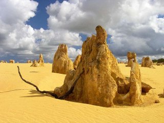
he Pinnacles are limestone formations contained within Nambung National Park, near the town of Cervantes, Western Australia. The raw material for the limestone of the Pinnacles came from seashells in an earlier epoch rich in marine life. These shells were broken down into lime rich sands which were blown inland to form high mobile dunes. The mechanisms through which the Pinnacles were formed from this raw material are the subject of some controversy, with three mechanisms having been proposed:
- they were formed from lime leaching from the aeolian sand (wind-blown sand) and by rain cementing the lower levels of the dune into a soft limestone. Vegetation forms an acidic layer of soil and humus. A hard cap of calcrete develops above the softer limestone. Cracks in the calcrete are exploited by plant roots. The softer limestone continues to dissolve and quartz sand fills the channels that form. Vegetation dies and winds blow away the sand covering the eroded limestone, thus revealing the Pinnacles.
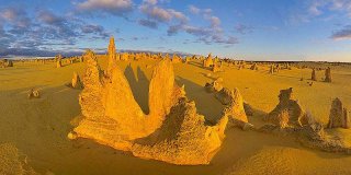 they were formed through the preservation of casts of trees buried in coastal aeolianites where roots became groundwater conduits, resulting in precipitation of indurated (hard) calcrete. Subsequent wind erosion of the aeolianite would then expose the calcrete pillars.
On the basis of the mechanism of formation of smaller root casts occurring in other parts of the world, it has been proposed that plants played an active role in the creation of the Pinnacles, rather than the rather passive role detailed above. The proposal is that as transpiration draws water through the soil to the roots, nutrients and other dissolved minerals flow toward the root.
This process is termed "mass-flow" and can result in the accumulation of nutrients at the surface of the root, if the nutrients arrive in quantities greater than needed for plant growth. In coastal aeolian sands which have large amounts of calcium (derived from marine shells) the movement of water to the roots would drive the flow of calcium to the root surface. This calcium accumulates at high concentrations around the roots and over time is converted into a calcrete. When the roots die, the space occupied by the root is subsequently also filled with a carbonate material derived from the calcium in the former tissue of the roots and possibly also from water leaching through the structures. Although evidence has been provided for this mechanism in the formation of root casts in South Africa, evidence is still required for its role in the formation of the Pinnacles.
Baiame
In Australian Aboriginal mythology Baiame (Baayami or Baayama) was the Creator God and Sky Father in the dreaming of several language groups (e.g. Kamilaroi, Eora, Darkinjung, and Wiradjuri), of Indigenous Australians of South-East Australia.
The Baiame myth tells how Baiame came down from the sky to the land, and created rivers, mountains, and forests. He then gave the people their laws of life, traditions, songs, and culture. He also created the first initiation site. This is known as a bora; a place where boys were initiated into manhood. When he had finished, he returned to the sky, and people called him the Sky Hero or All Father or Sky Father.
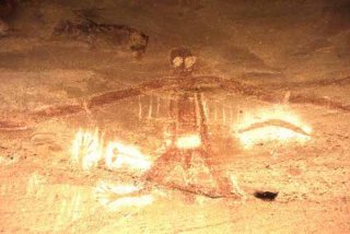 He is said to be married to Birrahgnooloo (Birran-gnulu), who is often identified as an emu, and with whom he has a son Daramulum (Dharramalan). In other stories Daramulum is said to be brother to Baiame. It was forbidden to mention or talk about the name of Baiame publicly. Women were not allowed to see drawings of Baiame nor approach Baiame sites - which are often male initiation sites (boras).
In rock paintings Baiame is often depicted as a human figure with a large head-dress or hairstyle, with lines of footsteps nearby. He is always painted in front view; Daramulum is drawn in profile. Baiame is often shown with internal decorations such as waistbands, vertical lines running down the body, bands and dots. The dots are said to have given him power over smallpox.
The missionary William Ridley adopted the name of Baiame for the Christian God when translating into Gamilaraay (the language of the Kamilaroi). It is sometimes suggested that Baiame was a construct of early Christian missionaries. Doubt is cast on this by a reference to Baiame apparently dating back to 1830-1840 by K Langloh Parker.
In the area surrounding Lake Macquarie in New South Wales, Australia, he was believed to have created all of the mountains, lakes, rivers and caves in the area. After he finished creating, he jumped back up to the spirit world from Mount Yengo, which he flattened. Its flat top can still be seen to this day, near Wollombi Valley. A cave near Milbrodale contains many Wiradjuri Aboriginal paintings, including a large figure of a man who may be Baiame. It is popularly known as the Baiame Cave and is part of a series of rock shelters on an area of 80 hectares. The site is listed on the Register of the National Estate. It depicts him with enormous, long, arms and large staring eyes.
During the Stolen Generation many tribes lost information about their culture, traditional beliefs, stories and ceremonies, and because Aboriginal customs were not written down and recorded, the effect of the Stolen Generation affected all. To the several local tribes, the Wiradjuri, Darkinjung, Wonnarua, Awabakal, Worimi, Biripi and Kamilaroi, it is another piece to the puzzle, helping them uncover lost ceremonies and traditions.
Flinders Ranges
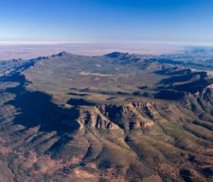
The Flinders Ranges is South Australia's largest mountain range which starts approximately 200 km north of Adelaide. The discontinuous ranges stretch for over 430 km from Port Pirie to Lake Callabonna. Its most characteristic landmark is Wilpena Pound, a large, sickle-shaped, natural amphitheatre covering nearly 80 square kilometres, containing the range's highest peak, St Mary Peak (1170m), and adjoining the Flinders Ranges National Park. The northern ranges host the Arkaroola wilderness sanctuary and the Vulkathunha-Gammon Ranges National Park. The southern part of the ranges are notable for the Pichi Richi scenic railway and Mount Remarkable National Park.
